


Marine Ways - Nautical Charts
คำอธิบายของMarine Ways - Nautical Charts
แอปพลิเคชันนี้ไม่มีส่วนเกี่ยวข้องกับ NOAA และไม่ได้เป็นตัวแทนของหน่วยงานรัฐบาลใด ๆ
แอปนี้ใช้แผนภูมิที่มีให้บริการฟรีจาก NOAA และแหล่งข้อมูลอื่นๆ ตามรายการด้านล่าง
https://charts.noaa.gov/ENCs/ENCs.shtml
https://www.linz.govt.nz/
https://www.weather.gov/
ข้อจำกัดความรับผิดชอบแผนภูมิการเดินเรือจาก NOAA:
NOAA ENC Online ไม่ได้รับการรับรองสำหรับการนำทาง การจับภาพหน้าจอของ ENC ที่แสดงที่นี่ไม่เป็นไปตามข้อกำหนดการขนส่งแบบแผนภูมิสำหรับเรือพาณิชย์ที่ได้รับการควบคุมภายใต้หัวข้อ 33 และ 46 ของประมวลกฎหมายรัฐบาลกลาง
Marine Ways Boating เป็นแอปพลิเคชั่นการนำทางและการวางแผนทางทะเลขั้นสูงสุด! ในแอปพลิเคชันนี้ คุณจะสามารถเข้าถึง:
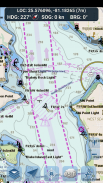
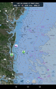
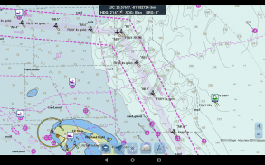
แผนภูมิการนำทาง
- แผนภูมิสหรัฐอเมริกาจัดทำโดย National Oceanic and Atmospheric Administration (NOAA)
https://charts.noaa.gov/ENCs/ENCs.shtml
- แผนภูมินิวซีแลนด์จัดทำโดย Land Information New Zealand (LINZ)
https://www.linz.govt.nz/
ประเภทแผนภูมิ:
- NOAA Electronic Navigational Charts (ENC) (ผลิตภัณฑ์สร้างแผนภูมิอิเล็กทรอนิกส์ใหม่ล่าสุดและทรงพลังที่สุดของ NOAA)
https://charts.noaa.gov/ENCs/ENCs.shtml
https://nauticalcharts.noaa.gov/
- แผนภูมิ NOAA แบบคลาสสิก (รวมถึงเวอร์ชัน Day, Red, Dusk, Night และ Grey)
- แผนภูมิ LINZ (ปัจจุบันมีให้บริการในเวอร์ชันกลางวัน ค่ำ และกลางคืนเท่านั้น)
https://www.linz.govt.nz/
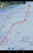
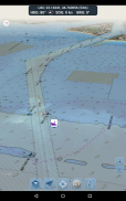
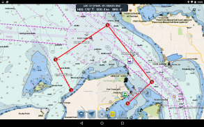
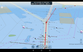
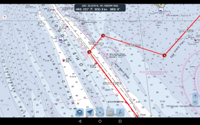
เครื่องมือการวางแผนเส้นทาง
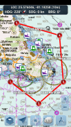
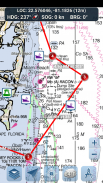
- การวางแผนเส้นทาง แตะบนแผนที่ค้างไว้หนึ่งวินาทีเพื่อวางแผนจุดอ้างอิงของคุณ หากต้องการสร้างเส้นทาง ให้แตะแผนที่ค้างไว้ในพื้นที่ต่างๆ ต่อไป ระยะทางและทิศทางได้รับการคำนวณและแสดงอย่างสะดวกสำหรับขาแต่ละข้างเมื่อคุณเพิ่ม ปรับ หรือลบเวย์พอยท์
-โหมดการเดินทาง จัดกึ่งกลางแผนที่บนตำแหน่งปัจจุบันของคุณโดยอัตโนมัติเมื่อคุณเคลื่อนที่ ใช้โหมดการเดินทางเพื่อดูว่าคุณกำลังติดตามเส้นทางที่วางแผนไว้แบบเรียลไทม์แค่ไหน!
สรุปเส้นทางขา มุมมองที่สะดวกซึ่งประกอบด้วยข้อมูลโดยละเอียดของแต่ละขาที่คุณวางแผนไว้ รวมถึงพิกัดเริ่มต้นและสิ้นสุด ระยะทาง และทิศทาง
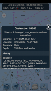
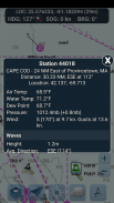
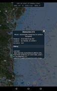
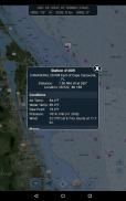
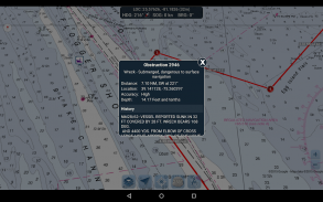
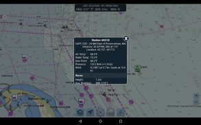
รายงานทุ่นและข้อมูลอุปสรรค
ข้อมูลที่ได้รับจาก: https://www.weather.gov/
เครื่องหมายทุ่นและสิ่งกีดขวางได้รับการลงจุดอย่างสะดวกในตำแหน่งจริงบนแผนที่! เพียงคลิกที่เครื่องหมายเพื่อดูข้อมูล!
- รายงานทุ่น: รับสภาพปัจจุบันที่สมบูรณ์และรายงานคลื่นสำหรับทุ่นคงที่และทุ่นลอย
https://www.weather.gov/
- อุปสรรค: รับข้อมูลตำแหน่งและประวัติเกี่ยวกับอันตรายที่อาจเกิดขึ้นและจมอยู่ใต้น้ำ รวมถึงหินและเรือที่จม
https://www.weather.gov/
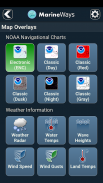
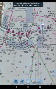
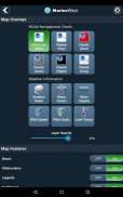
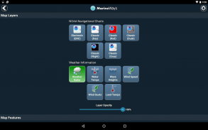
การซ้อนทับแผนที่ทางทะเล
สลับข้อมูลซ้อนทับทางทะเลต่างๆ ลงบนแผนที่โดยตรงเพื่อให้เข้าใจสภาพการเดินเรือในปัจจุบันได้ดีขึ้น!
ภาพซ้อนทับประกอบด้วย:
- อุณหภูมิพื้นผิวของน้ำ (ทั่วโลก)
- ความเร็วลม (สหรัฐอเมริกาเท่านั้น)
- ลมกระโชก (สหรัฐอเมริกาเท่านั้น)
- Wave Heights (สหรัฐอเมริกาเท่านั้น)
https://www.weather.gov/
การแบ่งปันตำแหน่งเหนือน้ำ / ดูเรือลำอื่น
- แสดงตำแหน่ง ความเร็ว ทิศทาง และชื่อเรือล่าสุดของคุณบนแผนที่เพื่อให้นักเดินเรือ Marine Ways คนอื่นๆ ดู
- ดูตำแหน่งที่ทราบล่าสุด ความเร็ว ทิศทาง และชื่อเรือของนักพายเรือ Marine Ways คนอื่นๆ รวมถึงระยะทางและทิศทางจากตำแหน่งของคุณ
- การแชร์ตำแหน่งจะถูกปิดตามค่าเริ่มต้น เมื่อคุณพร้อมที่จะแชร์ ให้เปิดใช้งานภายในการตั้งค่าทั่วไป หากต้องการอัปเดตตำแหน่งของคุณบนแผนที่อย่างต่อเนื่อง ให้เปิดแอปและโฟกัสไว้ ขณะนี้แอปไม่ได้อัปเดตตำแหน่งของคุณในเบื้องหลัง
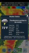
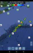
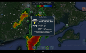
ข้อมูลสภาพอากาศ
- เรดาร์ตรวจสภาพอากาศ (สหรัฐอเมริกาและฮาวายเท่านั้น) ตรวจจับฝนและหิมะในพื้นที่
- สถานีตรวจอากาศ รายงานข้อมูลสถานีสังเกตการณ์ที่ใกล้ที่สุด อุณหภูมิปัจจุบัน ความชื้น สภาพอากาศ ลม และอื่นๆ อีกมากมาย! ข้อมูลการสังเกตสถานีมีให้บริการทั่วโลก
- การซ้อนทับอุณหภูมิพื้นผิวดิน แสดงอุณหภูมิพื้นผิวปัจจุบันบนบก (สหรัฐอเมริกาเท่านั้น)
ก่อนที่จะใช้แอปพลิเคชันนี้ โปรดอ่านและยอมรับข้อกำหนดการใช้งาน/บริการ และนโยบายความเป็นส่วนตัวต่อไปนี้:
ข้อกำหนดการใช้งาน / บริการ: http://www.marineways.com/appterms
นโยบายความเป็นส่วนตัว: http://www.marineways.com/appprivacy
สนุกกับแอพ! Marine Ways มีอยู่บนเว็บที่ http://www.marineways.com
Marine Ways - Nautical Charts--เวอร์ชั่น1.75
(02-04-2025)Marine Ways - Nautical Charts - ข้อมูล APK
เวอร์ชั่น APK: 1.75แพ็คเกจ: com.marineways.androidเวอร์ชั่นล่าสุดของMarine Ways - Nautical Charts
เวอร์ชั่นอื่น


แอปในประเภทเดียวกัน

คุณอาจจะชอบ...


